
Make a donation
Gear up for your next adventure:
As an Amazon Associate, this site earns from qualifying purchases at no extra cost to you.
Marlesreuth topographic map
Click on the map to display elevation.
Make a donation
Gear up for your next adventure:
As an Amazon Associate, this site earns from qualifying purchases at no extra cost to you.
Marlesreuth
Das Pfarrdorf liegt auf einem Höhenzug des Frankenwaldes und ist von Acker- und Grünland umgeben. Die Staatsstraße 2158 führt an Molkenbrunn vorbei zur Bundesstraße 173 bei Naila (2,5 km nördlich) bzw. nach Döbra zur Staatsstraße 2194 (3 km südwestlich). Die Kreisstraße HO 33 führt nach Selbitz zur Staatsstraße 2195 (4 km nordöstlich). Eine Gemeindeverbindungsstraße führt nach Haidengrün (1,5 km südlich). Auf dem Weg nach Selbitz ist das Naturdenkmal Kapfender Stein.
Make a donation
Gear up for your next adventure:
As an Amazon Associate, this site earns from qualifying purchases at no extra cost to you.
About this map
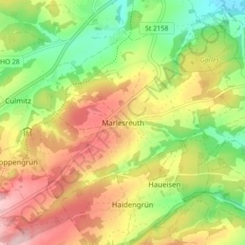
Name: Marlesreuth topographic map, elevation, terrain.
Location: Marlesreuth, Naila, Landkreis Hof, Bayern, 95119, Deutschland (50.27876 11.67380 50.31876 11.71380)
Average elevation: 595 m
Minimum elevation: 501 m
Maximum elevation: 696 m
Make a donation
Gear up for your next adventure:
As an Amazon Associate, this site earns from qualifying purchases at no extra cost to you.