
Make a donation
Gear up for your next adventure:
As an Amazon Associate, this site earns from qualifying purchases at no extra cost to you.
Fishguard topographic map
Click on the map to display elevation.
Make a donation
Gear up for your next adventure:
As an Amazon Associate, this site earns from qualifying purchases at no extra cost to you.
About this map
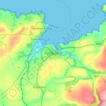
Name: Fishguard topographic map, elevation, terrain.
Location: Fishguard, Pembrokeshire, Wales, SA65 9AN, United Kingdom (51.95384 -5.01681 52.03384 -4.93681)
Average elevation: 76 m
Minimum elevation: 0 m
Maximum elevation: 263 m
Make a donation
Gear up for your next adventure:
As an Amazon Associate, this site earns from qualifying purchases at no extra cost to you.
Other topographic maps
Click on a map to view its topography, its elevation and its terrain.
Caldey Island
United Kingdom > Wales > Pembrokeshire
Caldey Island is about 1.5 miles (2.4 km) long and 1 mile (1.6 km) in width at its widest. It has an area of 538 acres (2.18 km2) and its highest elevation is 197 feet (60 m). The island lies in Carmarthen Bay on the northern side of the Bristol Channel in the county of Pembrokeshire, a little over 2.5 miles…
Average elevation: 5 m
Make a donation
Gear up for your next adventure:
As an Amazon Associate, this site earns from qualifying purchases at no extra cost to you.
Milford Haven
United Kingdom > Wales > Pembrokeshire
One of the earliest notable figures from the Milford Haven area is Howell Davis, a pirate born in 1680. He was shot dead in 1719 on the Portuguese island of Príncipe. Other famous residents connected as seafarers include Isaac Davis, a former seaman who was engaged in the fur trade between the Pacific…
Average elevation: 36 m