
Make a donation
Gear up for your next adventure:
As an Amazon Associate, this site earns from qualifying purchases at no extra cost to you.
Guallatiri topographic map
Click on the map to display elevation.
Make a donation
Gear up for your next adventure:
As an Amazon Associate, this site earns from qualifying purchases at no extra cost to you.
Guallatiri
Guallatiri has been active in historical times with a number of eruptions, the latest in 1960. Fumarolic and seismic activity is ongoing and has resulted in the deposition of sulfur and other minerals on the volcano. The volcano is covered by an ice cap above 5,500 metres (18,000 ft) elevation. Guallatiri, along with several other volcanoes, is part of Lauca National Park.
Make a donation
Gear up for your next adventure:
As an Amazon Associate, this site earns from qualifying purchases at no extra cost to you.
About this map
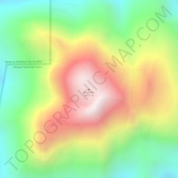
Name: Guallatiri topographic map, elevation, terrain.
Average elevation: 5,651 m
Minimum elevation: 5,278 m
Maximum elevation: 6,062 m
Make a donation
Gear up for your next adventure:
As an Amazon Associate, this site earns from qualifying purchases at no extra cost to you.