
Make a donation
Gear up for your next adventure:
As an Amazon Associate, this site earns from qualifying purchases at no extra cost to you.
Tazones topographic map
Click on the map to display elevation.
Make a donation
Gear up for your next adventure:
As an Amazon Associate, this site earns from qualifying purchases at no extra cost to you.
About this map
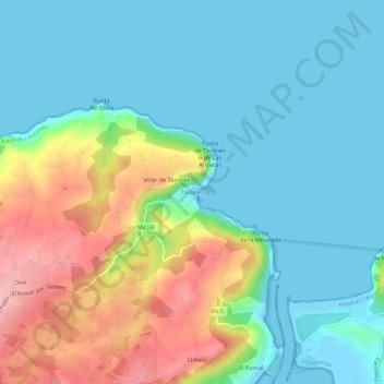
Name: Tazones topographic map, elevation, terrain.
Location: Tazones, Villaviciosa, Asturias, 33315, España (43.52539 -5.42020 43.56539 -5.38020)
Average elevation: 51 m
Minimum elevation: -5 m
Maximum elevation: 175 m
Make a donation
Gear up for your next adventure:
As an Amazon Associate, this site earns from qualifying purchases at no extra cost to you.
Other topographic maps
Click on a map to view its topography, its elevation and its terrain.
Selorio
España > Asturias > Villaviciosa
La aldea de Selorio se sitúa en la zona central del término parroquial a una altitud de 25 metros, distando 9 km de la capital municipal. Es de creación moderna, por agrupación de los núcleos de La Ariella, La Barquera, La Calle, La Chispa, Misiego, El Olivar, El Pandal, La Piniella, Rodiles y Terienzo.…
Average elevation: 77 m
Make a donation
Gear up for your next adventure:
As an Amazon Associate, this site earns from qualifying purchases at no extra cost to you.