
Make a donation
Gear up for your next adventure:
As an Amazon Associate, this site earns from qualifying purchases at no extra cost to you.
Bolano topographic map
Click on the map to display elevation.
Make a donation
Gear up for your next adventure:
As an Amazon Associate, this site earns from qualifying purchases at no extra cost to you.
About this map
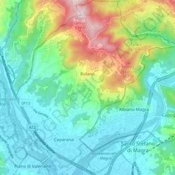
Name: Bolano topographic map, elevation, terrain.
Location: Bolano, La Spezia, Liguria, Italy (44.15635 9.86484 44.21041 9.93432)
Average elevation: 161 m
Minimum elevation: 14 m
Maximum elevation: 580 m
Make a donation
Gear up for your next adventure:
As an Amazon Associate, this site earns from qualifying purchases at no extra cost to you.
Other topographic maps
Click on a map to view its topography, its elevation and its terrain.
Make a donation
Gear up for your next adventure:
As an Amazon Associate, this site earns from qualifying purchases at no extra cost to you.
Monterosso al Mare
Italy > Liguria > La Spezia > Monterosso al Mare > Monterosso al Mare
Average elevation: 186 m
Montebello di Mezzo
Italy > Liguria > La Spezia > Bolano > Montebello di Mezzo
Average elevation: 235 m