
Make a donation
Gear up for your next adventure:
As an Amazon Associate, this site earns from qualifying purchases at no extra cost to you.
Sudbury topographic map
Click on the map to display elevation.
Make a donation
Gear up for your next adventure:
As an Amazon Associate, this site earns from qualifying purchases at no extra cost to you.
About this map
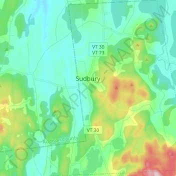
Name: Sudbury topographic map, elevation, terrain.
Location: Sudbury, Rutland County, Vermont, United States (43.74887 -73.23197 43.83967 -73.13148)
Average elevation: 163 m
Minimum elevation: 80 m
Maximum elevation: 433 m
Make a donation
Gear up for your next adventure:
As an Amazon Associate, this site earns from qualifying purchases at no extra cost to you.
Other topographic maps
Click on a map to view its topography, its elevation and its terrain.
Danby
United States > Vermont > Rutland County
Dorset Peak, part of the Taconic range, lies on the town's southern border and reaches an elevation of 3,804 feet (1,159 m). Danby quarry, located near the peak, opened in the early 20th century and is likely the world's largest underground marble quarry. It was reported in 2001 to have a total monthly output…
Average elevation: 303 m
Make a donation
Gear up for your next adventure:
As an Amazon Associate, this site earns from qualifying purchases at no extra cost to you.
Valley Park
United States > Vermont > Rutland County > Killington > Sherburne Center
Average elevation: 506 m
Make a donation
Gear up for your next adventure:
As an Amazon Associate, this site earns from qualifying purchases at no extra cost to you.