
Make a donation
Gear up for your next adventure:
As an Amazon Associate, this site earns from qualifying purchases at no extra cost to you.
Antietam topographic map
Click on the map to display elevation.
Make a donation
Gear up for your next adventure:
As an Amazon Associate, this site earns from qualifying purchases at no extra cost to you.
About this map
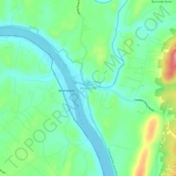
Name: Antietam topographic map, elevation, terrain.
Location: Antietam, Washington County, Maryland, 21782, United States (39.39621 -77.76222 39.43621 -77.72222)
Average elevation: 123 m
Minimum elevation: 85 m
Maximum elevation: 217 m
Make a donation
Gear up for your next adventure:
As an Amazon Associate, this site earns from qualifying purchases at no extra cost to you.
Other topographic maps
Click on a map to view its topography, its elevation and its terrain.
Hagerstown
United States > Maryland > Washington County
Hagerstown has a distinct topography, formed by stone ridges running from northeast to southwest through the center of town. Geography accordingly bounds its neighborhoods. These ridges consist of upper Stonehenge limestone. Many of the older buildings were built from this stone, which is easily quarried and…
Average elevation: 170 m
Make a donation
Gear up for your next adventure:
As an Amazon Associate, this site earns from qualifying purchases at no extra cost to you.
Antietam National Battlefield
United States > Maryland > Washington County > Sharpsburg
Average elevation: 147 m
Make a donation
Gear up for your next adventure:
As an Amazon Associate, this site earns from qualifying purchases at no extra cost to you.
Hagerstown
United States > Maryland > Washington County
Hagerstown has a distinct topography, formed by stone ridges running from northeast to southwest through the center of town. Geography accordingly bounds its neighborhoods. These ridges consist of upper Stonehenge Limestone. Many of the older buildings were built from this stone, which is easily quarried and…
Average elevation: 170 m
Make a donation
Gear up for your next adventure:
As an Amazon Associate, this site earns from qualifying purchases at no extra cost to you.
South Mountain State Park
United States > Maryland > Washington County > Mount Lena
Average elevation: 201 m
Make a donation
Gear up for your next adventure:
As an Amazon Associate, this site earns from qualifying purchases at no extra cost to you.