
Make a donation
Gear up for your next adventure:
As an Amazon Associate, this site earns from qualifying purchases at no extra cost to you.
Kythira topographic map
Click on the map to display elevation.
Make a donation
Gear up for your next adventure:
As an Amazon Associate, this site earns from qualifying purchases at no extra cost to you.
About this map
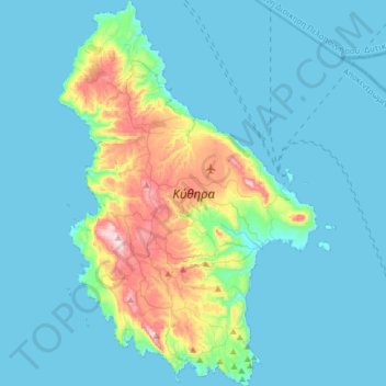
Name: Kythira topographic map, elevation, terrain.
Location: Kythira, Regional Unit of Islands, Attica, Greece (36.13024 22.89101 36.38578 23.10492)
Average elevation: 75 m
Minimum elevation: 0 m
Maximum elevation: 502 m
Make a donation
Gear up for your next adventure:
As an Amazon Associate, this site earns from qualifying purchases at no extra cost to you.
Other topographic maps
Click on a map to view its topography, its elevation and its terrain.
Methana
Greece > Attica > Regional Unit of Islands > Municipal Unit of Methana
Since 1991, the peninsula has been investigated by the team of ETH Zürich geologically and cartographically. From this, a topographical map of the entire peninsula at a scale of 1:25,000 was made. An interactive 3D map was created and is on the World Wide Web. Also a rich photographic archive with about…
Average elevation: 123 m
Ευαγγελίστριας
Greece > Attica > Regional Unit of Islands > Salamina Municipal Unit > Σατερλί
Average elevation: 23 m
Make a donation
Gear up for your next adventure:
As an Amazon Associate, this site earns from qualifying purchases at no extra cost to you.