
Make a donation
Gear up for your next adventure:
As an Amazon Associate, this site earns from qualifying purchases at no extra cost to you.
Meljak topographic map
Click on the map to display elevation.
Make a donation
Gear up for your next adventure:
As an Amazon Associate, this site earns from qualifying purchases at no extra cost to you.
About this map
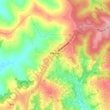
Name: Meljak topographic map, elevation, terrain.
Average elevation: 199 m
Minimum elevation: 123 m
Maximum elevation: 273 m
Make a donation
Gear up for your next adventure:
As an Amazon Associate, this site earns from qualifying purchases at no extra cost to you.
Other topographic maps
Click on a map to view its topography, its elevation and its terrain.
Siljakovac
Serbia > Central Serbia > City of Belgrade > Barajevo Urban Municipality
Average elevation: 164 m
Barajevo
Serbia > Central Serbia > City of Belgrade > Barajevo Urban Municipality
The municipality is located in the lower northern part of Šumadija, southeast of the Belgrade, with an elevation spanning from 140 meters to 364 meters. Most of the municipal territory belongs to the drainage area of the Turija river, right tributary of the Peštan river, which in turn flows into the…
Average elevation: 175 m
Manic
Serbia > Central Serbia > City of Belgrade > Barajevo Urban Municipality
Average elevation: 177 m
Lisovic
Serbia > Central Serbia > City of Belgrade > Barajevo Urban Municipality
Average elevation: 206 m
Make a donation
Gear up for your next adventure:
As an Amazon Associate, this site earns from qualifying purchases at no extra cost to you.
Rozanci
Serbia > Central Serbia > City of Belgrade > Barajevo Urban Municipality
Average elevation: 161 m
Veliki Borak
Serbia > Central Serbia > City of Belgrade > Barajevo Urban Municipality
Average elevation: 149 m
Bozdarevac
Serbia > Central Serbia > City of Belgrade > Barajevo Urban Municipality
Average elevation: 160 m
Guncati
Serbia > Central Serbia > City of Belgrade > Barajevo Urban Municipality
Average elevation: 189 m
Make a donation
Gear up for your next adventure:
As an Amazon Associate, this site earns from qualifying purchases at no extra cost to you.