
Thank you for supporting this site ❤️
Make a donation
Make a donation
Gear up for your next adventure:
As an Amazon Associate, this site earns from qualifying purchases at no extra cost to you.
Zorba topographic map
Click on the map to display elevation.
Thank you for supporting this site ❤️
Make a donation
Make a donation
Gear up for your next adventure:
As an Amazon Associate, this site earns from qualifying purchases at no extra cost to you.
About this map
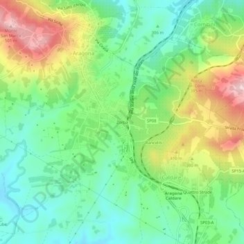
Name: Zorba topographic map, elevation, terrain.
Location: Zorba, Caldare, Aragona, Agrigento, Sicilia, 92021, Italia (37.37186 13.60594 37.41186 13.64594)
Average elevation: 338 m
Minimum elevation: 246 m
Maximum elevation: 500 m
Thank you for supporting this site ❤️
Make a donation
Make a donation
Gear up for your next adventure:
As an Amazon Associate, this site earns from qualifying purchases at no extra cost to you.