Geolocate

Les Rots topographic map

Click on the map to display elevation.

About this map

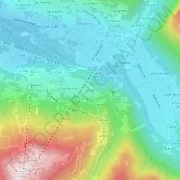
Name: Les Rots topographic map, elevation, terrain.

Location: Les Rots, Samoëns, Bonneville, Haute-Savoie, Auvergne-Rhône-Alpes, France métropolitaine, 74340, France (46.05121 6.69934 46.09121 6.73934)

Average elevation: 936 m

Minimum elevation: 673 m

Maximum elevation: 1,631 m

Other topographic maps

Click on a map to view its topography, its elevation and its terrain.

Lac de Gers

France > Auvergne-Rhône-Alpes > Haute-Savoie > Samoëns > Chalets de Gers

Le lac de Gers est un lac situé sur la commune de Samoëns, en Haute-Savoie, qui culmine à 1 537 m d'altitude.

Average elevation: 1,762 m

Gear up for your next adventure:

🛶Kayak Accessories - Essential gear for safe and fun kayaking adventures
🥾Trail Running Shoes - Lightweight and durable shoes for trail running
💡Portable Camping Lamp - Rechargeable lamp for campsite lighting
🥾All-Terrain Hiking Boots - Versatile boots for varied hiking conditions
🧥Thermal Fleece Jacket - Versatile insulation for changing mountain temperatures

As an Amazon Associate, this site earns from qualifying purchases at no extra cost to you.