Geolocate

Nampa topographic map

Click on the map to display elevation.

About this map

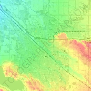
Name: Nampa topographic map, elevation, terrain.

Location: Nampa, Canyon County, Idaho, United States (43.52346 -116.64415 43.65588 -116.47352)

Average elevation: 764 m

Minimum elevation: 733 m

Maximum elevation: 818 m

Other topographic maps

Click on a map to view its topography, its elevation and its terrain.

Fischer Island

United States > Idaho > Canyon County

Average elevation: 729 m

Gear up for your next adventure:

Camping Essentials - All-in-one gear for a comfortable camping trip
🎒Hiking Daypack - Lightweight and durable backpacks for day trips and excursions
🥾Hiking Shoes - Durable and comfortable shoes for trail hiking
🔋Emergency Crank Radio - Weather alerts and power without needing batteries
🔭Compact Monocular - One-handed bird watching and trail spotting

As an Amazon Associate, this site earns from qualifying purchases at no extra cost to you.