Geolocate

Terrusso topographic map

Click on the map to display elevation.

About this map

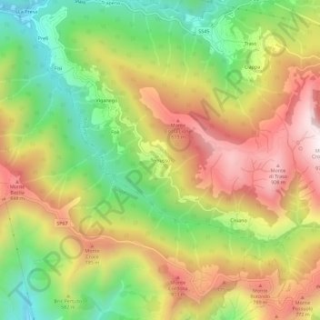
Name: Terrusso topographic map, elevation, terrain.

Location: Terrusso, Bargagli, Genoa, Liguria, 16021, Italy (44.40236 9.05297 44.44236 9.09297)

Average elevation: 546 m

Minimum elevation: 156 m

Maximum elevation: 962 m

Gear up for your next adventure:

🩹Moleskin Blister Pads - Direct protection for painful foot pressure points
🥾Trekking Boots - Durable boots for long-distance trekking
🧦Hiking Socks - Moisture-wicking and comfortable socks for long hikes
🥾Hiking Shoes - Durable and comfortable shoes for trail hiking
🦶Hiking Shoe Insoles - Added support for high arches and long days on feet

As an Amazon Associate, this site earns from qualifying purchases at no extra cost to you.