
Make a donation
Gear up for your next adventure:
As an Amazon Associate, this site earns from qualifying purchases at no extra cost to you.
Mouzon topographic map
Click on the map to display elevation.
Make a donation
Gear up for your next adventure:
As an Amazon Associate, this site earns from qualifying purchases at no extra cost to you.
Mouzon
La Meuse, d'une longueur de 486 km, est un fleuve européen qui prend sa source en France, dans la commune du Châtelet-sur-Meuse, à 409 mètres d'altitude, et se jette dans la mer du Nord après un cours long d'approximativement 950 kilomètres traversant la France, la Belgique et les Pays-Bas. Elle s'écoule du sud vers le nord et traverse la commune sur une longueur d'environ 13,7 km, constituant sur son flanc nord-ouest une limite séparative avec la commune d'Autrecourt-et-Pourron.
Make a donation
Gear up for your next adventure:
As an Amazon Associate, this site earns from qualifying purchases at no extra cost to you.
About this map
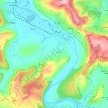
Name: Mouzon topographic map, elevation, terrain.
Average elevation: 212 m
Minimum elevation: 150 m
Maximum elevation: 342 m
Make a donation
Gear up for your next adventure:
As an Amazon Associate, this site earns from qualifying purchases at no extra cost to you.