Geolocate

Rheban topographic map

Click on the map to display elevation.

About this map

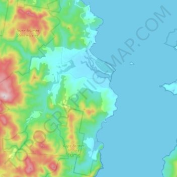
Name: Rheban topographic map, elevation, terrain.

Location: Rheban, Glamorgan-Spring Bay, Tasmania, Australia (-42.73507 147.82485 -42.59112 147.96291)

Average elevation: 112 m

Minimum elevation: -1 m

Maximum elevation: 621 m

Other topographic maps

Click on a map to view its topography, its elevation and its terrain.

Frog Hill

Australia > Tasmania

Average elevation: 875 m

Mount Kate

Australia > Tasmania

Average elevation: 995 m

Tasman Peninsula

Australia > Tasmania > Tasman > Fortescue

Average elevation: 167 m

Mount Jukes

Australia > Tasmania

Average elevation: 773 m

Ulverstone

Australia > Tasmania > Ulverstone

Average elevation: 37 m

Bullock Hill

Australia > Tasmania > Grove

Average elevation: 147 m

Highland Waters

Australia > Tasmania > London Lakes

Average elevation: 759 m

Stillwater Hill

Australia > Tasmania

Average elevation: 353 m

Legges Tor

Australia > Tasmania

Average elevation: 1,457 m

Rowlands Hill

Australia > Tasmania

Average elevation: 388 m

Recherche Bay

Australia > Tasmania

Average elevation: 10 m

Bastyan Dam

Australia > Tasmania > Tullah

Average elevation: 233 m

Gear up for your next adventure:

🧥Ultralight Puffy Jacket - Maximum warmth that packs down to the size of an orange
🥾Trail Hiking Socks - Comfortable socks to prevent blisters and fatigue
🧦Crew Hiking Socks - Comfortable socks for long-distance hikes
🧥Waterproof Hiking Jacket - Protect yourself from rain and wind while hiking
🧰Emergency Multi-Tool - Compact multi-tool for outdoor survival

As an Amazon Associate, this site earns from qualifying purchases at no extra cost to you.