
Make a donation
Gear up for your next adventure:
As an Amazon Associate, this site earns from qualifying purchases at no extra cost to you.
Anderlingen topographic map
Click on the map to display elevation.
Make a donation
Gear up for your next adventure:
As an Amazon Associate, this site earns from qualifying purchases at no extra cost to you.
About this map
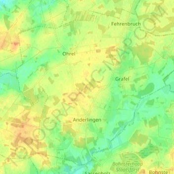
Name: Anderlingen topographic map, elevation, terrain.
Average elevation: 26 m
Minimum elevation: 12 m
Maximum elevation: 40 m
Make a donation
Gear up for your next adventure:
As an Amazon Associate, this site earns from qualifying purchases at no extra cost to you.
Other topographic maps
Click on a map to view its topography, its elevation and its terrain.
Kuhstedtermoor
Deutschland > Niedersachsen > Landkreis Rotenburg (Wümme) > Gnarrenburg
Average elevation: 7 m
Oberfindorf
Deutschland > Niedersachsen > Landkreis Rotenburg (Wümme) > Gnarrenburg
Average elevation: 6 m
Make a donation
Gear up for your next adventure:
As an Amazon Associate, this site earns from qualifying purchases at no extra cost to you.
Rübehorst
Deutschland > Niedersachsen > Landkreis Rotenburg (Wümme) > Gnarrenburg > Brillit
Average elevation: 23 m
Neu Kuhstedtermoor
Deutschland > Niedersachsen > Landkreis Rotenburg (Wümme) > Gnarrenburg
Average elevation: 8 m
Make a donation
Gear up for your next adventure:
As an Amazon Associate, this site earns from qualifying purchases at no extra cost to you.
Am Großen Bullensee
Deutschland > Niedersachsen > Landkreis Rotenburg (Wümme) > Kirchwalsede
Average elevation: 34 m
Jeersdorf
Deutschland > Niedersachsen > Landkreis Rotenburg (Wümme) > Scheeßel
Scheeßel liegt in der zur Stader Geest gehörenden Wümmeniederung unweit der Nordheide in einer Höhe von etwa 30 m ü. NHN. Durch den Ort fließen die Wümme und die Beeke. Die Umgebung wird geprägt durch Wälder, Wiesen und Moore (Geestlandschaft).
Average elevation: 31 m
Make a donation
Gear up for your next adventure:
As an Amazon Associate, this site earns from qualifying purchases at no extra cost to you.
Winkeldorf
Deutschland > Niedersachsen > Landkreis Rotenburg (Wümme) > Winkeldorf
Average elevation: 38 m
Brüttendorf
Deutschland > Niedersachsen > Landkreis Rotenburg (Wümme) > Zeven > Brüttendorf
Average elevation: 29 m
Hesedorf
Deutschland > Niedersachsen > Landkreis Rotenburg (Wümme) > Bremervörde
Average elevation: 18 m
Make a donation
Gear up for your next adventure:
As an Amazon Associate, this site earns from qualifying purchases at no extra cost to you.
Brillit
Deutschland > Niedersachsen > Landkreis Rotenburg (Wümme) > Gnarrenburg
Average elevation: 28 m
Make a donation
Gear up for your next adventure:
As an Amazon Associate, this site earns from qualifying purchases at no extra cost to you.
Nieder Ochtenhausen
Deutschland > Niedersachsen > Landkreis Rotenburg (Wümme) > Bremervörde
Average elevation: 5 m
Kuhstedt
Deutschland > Niedersachsen > Landkreis Rotenburg (Wümme) > Gnarrenburg
Average elevation: 22 m
Make a donation
Gear up for your next adventure:
As an Amazon Associate, this site earns from qualifying purchases at no extra cost to you.
Klenkendorf
Deutschland > Niedersachsen > Landkreis Rotenburg (Wümme) > Gnarrenburg
Average elevation: 9 m
Karlshöfenermoor
Deutschland > Niedersachsen > Landkreis Rotenburg (Wümme) > Gnarrenburg
Average elevation: 5 m
Make a donation
Gear up for your next adventure:
As an Amazon Associate, this site earns from qualifying purchases at no extra cost to you.
Offensen
Deutschland > Niedersachsen > Landkreis Rotenburg (Wümme) > Heeslingen
Average elevation: 23 m
Make a donation
Gear up for your next adventure:
As an Amazon Associate, this site earns from qualifying purchases at no extra cost to you.
Domäne Luhne
Deutschland > Niedersachsen > Landkreis Rotenburg (Wümme) > Rotenburg
Average elevation: 31 m
Fahrendorf
Deutschland > Niedersachsen > Landkreis Rotenburg (Wümme) > Gnarrenburg
Average elevation: 7 m
Make a donation
Gear up for your next adventure:
As an Amazon Associate, this site earns from qualifying purchases at no extra cost to you.
Langenhausen
Deutschland > Niedersachsen > Landkreis Rotenburg (Wümme) > Gnarrenburg
Average elevation: 11 m
Jeddingen
Deutschland > Niedersachsen > Landkreis Rotenburg (Wümme) > Visselhövede
Average elevation: 54 m
Ottendorf
Deutschland > Niedersachsen > Landkreis Rotenburg (Wümme) > Bremervörde
Average elevation: 2 m
Make a donation
Gear up for your next adventure:
As an Amazon Associate, this site earns from qualifying purchases at no extra cost to you.
Drögenbostel
Deutschland > Niedersachsen > Landkreis Rotenburg (Wümme) > Visselhövede
Average elevation: 66 m
Wehldorfer Holz
Deutschland > Niedersachsen > Landkreis Rotenburg (Wümme) > Wehldorf
Average elevation: 28 m
Hatzte Waldsiedlung
Deutschland > Niedersachsen > Landkreis Rotenburg (Wümme) > Elsdorf
Average elevation: 28 m
Make a donation
Gear up for your next adventure:
As an Amazon Associate, this site earns from qualifying purchases at no extra cost to you.
Neu Ebersdorf
Deutschland > Niedersachsen > Landkreis Rotenburg (Wümme) > Ebersdorf
Average elevation: 11 m
Geestequelle
Deutschland > Niedersachsen > Landkreis Rotenburg (Wümme) > Hipstedt > Hof Freitag
Average elevation: 20 m
Hof Emmen
Deutschland > Niedersachsen > Landkreis Rotenburg (Wümme) > Scheeßel > Westerholz
Average elevation: 32 m
Ziegeleiberg
Deutschland > Niedersachsen > Landkreis Rotenburg (Wümme) > Bötersen
Average elevation: 35 m
Make a donation
Gear up for your next adventure:
As an Amazon Associate, this site earns from qualifying purchases at no extra cost to you.
Stellingsmoor
Deutschland > Niedersachsen > Landkreis Rotenburg (Wümme) > Wehldorf
Average elevation: 30 m
Ober Klenkendorf
Deutschland > Niedersachsen > Landkreis Rotenburg (Wümme) > Gnarrenburg
Average elevation: 9 m
Make a donation
Gear up for your next adventure:
As an Amazon Associate, this site earns from qualifying purchases at no extra cost to you.
Ostervesede
Deutschland > Niedersachsen > Landkreis Rotenburg (Wümme) > Scheeßel
Average elevation: 37 m
Twistenbostel
Deutschland > Niedersachsen > Landkreis Rotenburg (Wümme) > Heeslingen
Average elevation: 23 m
Make a donation
Gear up for your next adventure:
As an Amazon Associate, this site earns from qualifying purchases at no extra cost to you.
Karlshöfen
Deutschland > Niedersachsen > Landkreis Rotenburg (Wümme) > Gnarrenburg
Average elevation: 9 m
Brockel Bahnhof
Deutschland > Niedersachsen > Landkreis Rotenburg (Wümme) > Brockel
Average elevation: 32 m
Make a donation
Gear up for your next adventure:
As an Amazon Associate, this site earns from qualifying purchases at no extra cost to you.
Sellhorn
Deutschland > Niedersachsen > Landkreis Rotenburg (Wümme) > Heeslingen > Sellhorn
Average elevation: 35 m
Oldendorf
Deutschland > Niedersachsen > Landkreis Rotenburg (Wümme) > Zeven > Oldendorf
Average elevation: 30 m
Hiddingen
Deutschland > Niedersachsen > Landkreis Rotenburg (Wümme) > Visselhövede
Average elevation: 62 m
Make a donation
Gear up for your next adventure:
As an Amazon Associate, this site earns from qualifying purchases at no extra cost to you.
Hönau-Lindorf
Deutschland > Niedersachsen > Landkreis Rotenburg (Wümme) > Bremervörde > Hönau-Lindorf
Average elevation: 4 m
Westeresch
Deutschland > Niedersachsen > Landkreis Rotenburg (Wümme) > Scheeßel > Westeresch
Average elevation: 35 m
Make a donation
Gear up for your next adventure:
As an Amazon Associate, this site earns from qualifying purchases at no extra cost to you.
Westerholz
Deutschland > Niedersachsen > Landkreis Rotenburg (Wümme) > Westerholz
Average elevation: 34 m
Mulmshorn
Deutschland > Niedersachsen > Landkreis Rotenburg (Wümme) > Rotenburg > Mulmshorn
Average elevation: 28 m
Iselersheim
Deutschland > Niedersachsen > Landkreis Rotenburg (Wümme) > Bremervörde
Average elevation: 2 m
Make a donation
Gear up for your next adventure:
As an Amazon Associate, this site earns from qualifying purchases at no extra cost to you.