
Make a donation
Gear up for your next adventure:
As an Amazon Associate, this site earns from qualifying purchases at no extra cost to you.
Region of Prešov topographic map
Click on the map to display elevation.
Make a donation
Gear up for your next adventure:
As an Amazon Associate, this site earns from qualifying purchases at no extra cost to you.
About this map
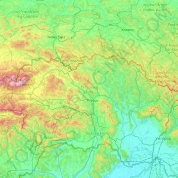
Name: Region of Prešov topographic map, elevation, terrain.
Location: Region of Prešov, Eastern Slovakia, Slovakia (48.76256 19.88393 49.46094 22.56571)
Average elevation: 444 m
Minimum elevation: 92 m
Maximum elevation: 2,591 m
Make a donation
Gear up for your next adventure:
As an Amazon Associate, this site earns from qualifying purchases at no extra cost to you.
Other topographic maps
Click on a map to view its topography, its elevation and its terrain.
Tatranská Lomnica
Slovakia > Region of Prešov > District of Poprad > Vysoké Tatry
Average elevation: 915 m
Vysoké Tatry - Starý Smokovec
Slovakia > Region of Prešov > District of Poprad > Vysoké Tatry
Average elevation: 1,069 m
Veľký Biel
Slovakia > Region of Bratislava > District of Senec
The municipality lies at an altitude of 131 metres and covers an area of 10.161 km². It has a population of 2303 people.
Average elevation: 130 m
Make a donation
Gear up for your next adventure:
As an Amazon Associate, this site earns from qualifying purchases at no extra cost to you.
Suchá Belá
Slovakia > Region of Košice > District of Spišská Nová Ves > Hrabušice
Average elevation: 781 m
Sedmák
Slovakia > Region of Banská Bystrica > District of Brezno > Čierny Balog
Average elevation: 924 m
Teplice
Slovakia > Region of Žilina > District of Liptovský Mikuláš > Bobrovec
Average elevation: 739 m
Make a donation
Gear up for your next adventure:
As an Amazon Associate, this site earns from qualifying purchases at no extra cost to you.
Czerwone Wierchy / Červené vrchy
Slovakia > Region of Prešov > District of Poprad > Vysoké Tatry
Average elevation: 1,730 m
Jasná
Slovakia > Region of Žilina > District of Liptovský Mikuláš > Demanovska Valley
Average elevation: 1,264 m
Jasina od Šťavia
Slovakia > Region of Prešov > District of Vranov nad Topľou > Rudlov
Average elevation: 599 m
Podskalský Roháč
Slovakia > Region of Trenčín > District of Považská Bystrica > Podskalie
Average elevation: 516 m
Make a donation
Gear up for your next adventure:
As an Amazon Associate, this site earns from qualifying purchases at no extra cost to you.
Vysoké Tatry - Tatranské Matliare
Slovakia > Region of Prešov > District of Poprad > Vysoké Tatry
Average elevation: 900 m
Michalovce
Slovakia > Region of Košice > District of Michalovce > Michalovce > Michalovce
Average elevation: 113 m
Make a donation
Gear up for your next adventure:
As an Amazon Associate, this site earns from qualifying purchases at no extra cost to you.
Poprad
Slovakia > Region of Prešov > District of Poprad > Poprad > Poprad
International Poprad–Tatry Airport from 1938, is an airport with the highest elevations in Central Europe. It also offers scheduled flights to London.
Average elevation: 699 m
Prievidza
Slovakia > Region of Trenčín > District of Prievidza > Prievidza > Prievidza
Average elevation: 332 m
Minca
Slovakia > Region of Banská Bystrica > District of Banská Bystrica > Strelníky
Average elevation: 892 m
Make a donation
Gear up for your next adventure:
As an Amazon Associate, this site earns from qualifying purchases at no extra cost to you.
Chorvátsky Grob
Slovakia > Region of Bratislava > District of Senec > Chorvátsky Grob > Chorvátsky Grob
Average elevation: 141 m
Markovce
Slovakia > Region of Košice > District of Michalovce > Markovce > Markovce
Average elevation: 103 m
Make a donation
Gear up for your next adventure:
As an Amazon Associate, this site earns from qualifying purchases at no extra cost to you.
Gápel
Slovakia > Region of Trenčín > District of Prievidza > Valaská Belá > Gápel
Average elevation: 652 m