
Make a donation
Gear up for your next adventure:
As an Amazon Associate, this site earns from qualifying purchases at no extra cost to you.
Westende-Bad topographic map
Click on the map to display elevation.
Make a donation
Gear up for your next adventure:
As an Amazon Associate, this site earns from qualifying purchases at no extra cost to you.
About this map
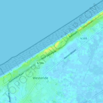
Name: Westende-Bad topographic map, elevation, terrain.
Average elevation: 2 m
Minimum elevation: -4 m
Maximum elevation: 20 m
Make a donation
Gear up for your next adventure:
As an Amazon Associate, this site earns from qualifying purchases at no extra cost to you.
Other topographic maps
Click on a map to view its topography, its elevation and its terrain.
Wenduine
Belgique > Flandre-Occidentale > Ostende
Un projet de construction d'une île artificielle contenant un grand puits de 30 m de profondeur et destiné au stockage de l'électricité éolienne du champ éolien offshore proche de la mer du Nord (2 300 MW de capacité globale espérés en 2020) a été proposé début 2013 au comité portuaire de…
Average elevation: 1 m
Make a donation
Gear up for your next adventure:
As an Amazon Associate, this site earns from qualifying purchases at no extra cost to you.