Geolocate

Euloz topographic map

Click on the map to display elevation.

About this map

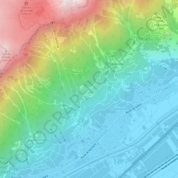
Name: Euloz topographic map, elevation, terrain.

Location: Euloz, Fully, Martigny, Wallis, 1926, Switzerland (46.13008 7.09535 46.17008 7.13535)

Average elevation: 1,023 m

Minimum elevation: 459 m

Maximum elevation: 2,419 m

Other topographic maps

Click on a map to view its topography, its elevation and its terrain.

Riddes

Switzerland > Wallis > Martigny

Average elevation: 1,410 m

Trient

Switzerland > Wallis > Martigny

Average elevation: 2,019 m

Gear up for your next adventure:

🛶Canoe Life Vest - Safety vest for water sports
💧Collapsible Water Bottle - Space-saving water bottle for outdoor activities
💡LED Camping Lantern - Illuminate your campsite with long-lasting lanterns
🥾Waterproof Hiking Shoes - Durable shoes for wet and rugged trails
🥾Light Hiking Boots - Lightweight and comfortable boots for day hikes

As an Amazon Associate, this site earns from qualifying purchases at no extra cost to you.