Geolocate

Portole topographic map

Click on the map to display elevation.

About this map

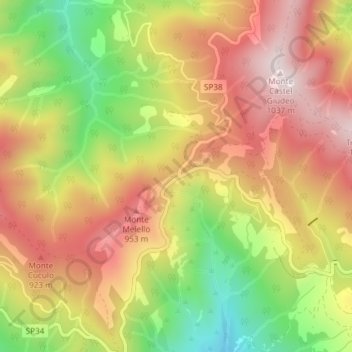
Name: Portole topographic map, elevation, terrain.

Location: Portole, Cortona, Arezzo, Tuscany, 52044, Italy (43.28890 12.03044 43.30890 12.05044)

Average elevation: 779 m

Minimum elevation: 478 m

Maximum elevation: 1,022 m

Gear up for your next adventure:

🧦Hiking Liner Socks - Thin base layer to prevent friction and blisters
🥾Hiking Shorts - Breathable shorts suitable for summer hikes
🍽️Titanium Camping Spork - Ultralight and indestructible eating utensil
🥾Approach Shoes - Shoes designed for climbing approaches and rugged trails
🥾Waterproof Hiking Boots - Boots keeping your feet dry in wet conditions

As an Amazon Associate, this site earns from qualifying purchases at no extra cost to you.