
Make a donation
Gear up for your next adventure:
As an Amazon Associate, this site earns from qualifying purchases at no extra cost to you.
Czarny Potok topographic map
Click on the map to display elevation.
Make a donation
Gear up for your next adventure:
As an Amazon Associate, this site earns from qualifying purchases at no extra cost to you.
About this map
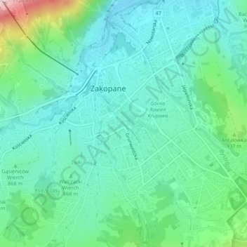
Name: Czarny Potok topographic map, elevation, terrain.
Average elevation: 869 m
Minimum elevation: 798 m
Maximum elevation: 1,114 m
Make a donation
Gear up for your next adventure:
As an Amazon Associate, this site earns from qualifying purchases at no extra cost to you.
Other topographic maps
Click on a map to view its topography, its elevation and its terrain.
Czarny Staw Gąsienicowy
Poland > Lesser Poland Voivodeship > Tatra County > Zakopane
Average elevation: 1,799 m
Tatry
Poland > Lesser Poland Voivodeship > Tatra County > Zakopane
The Tatras lie in the temperate zone of Central Europe. They are an important barrier to the movements of air masses. Their mountainous topography causes one of the most diverse climates in that region.
Average elevation: 1,647 m
Make a donation
Gear up for your next adventure:
As an Amazon Associate, this site earns from qualifying purchases at no extra cost to you.
Wielki Giewont
Poland > Lesser Poland Voivodeship > Tatra County > Zakopane
Average elevation: 1,478 m