Geolocate

Imués topographic map

Click on the map to display elevation.

About this map

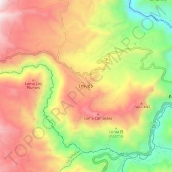
Name: Imués topographic map, elevation, terrain.

Location: Imués, La Sabana, Nariño, RAP Pacífico, Colombia (1.01547 -77.53583 1.09547 -77.45583)

Average elevation: 2,336 m

Minimum elevation: 1,535 m

Maximum elevation: 3,129 m

Gear up for your next adventure:

🥾Hiking Boots - Sturdy boots providing ankle support and traction on rugged trails
🧥Softshell Hiking Jacket - The perfect balance of wind protection and breathability
🚲Bike Repair Kit - Essential tools for on-trail mechanical issues
🕶️Polarized Sunglasses - Protect your eyes with durable polarized lenses
🦶Anti-Blister Balm - Prevents friction and hotspots during long ascents

As an Amazon Associate, this site earns from qualifying purchases at no extra cost to you.