Geolocate

Alapan II-B topographic map

Click on the map to display elevation.

About this map
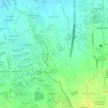
Name: Alapan II-B topographic map, elevation, terrain.

Location: Alapan II-B, Imus, Cavite, Calabarzon, 4103, Philippines (14.38514 120.90017 14.40482 120.91857)

Average elevation: 19 m

Minimum elevation: 10 m

Maximum elevation: 30 m

Other topographic maps

Click on a map to view its topography, its elevation and its terrain.

Bayan Luma VI

Philippines > Cavite > Imus > Bayan Luma VI

Average elevation: 18 m

Palico IV

Philippines > Cavite > Imus > Palico IV

Average elevation: 13 m

Pag-asa I

Philippines > Cavite > Imus > Pag-asa I

Average elevation: 8 m

Malagasang 2-A

Philippines > Cavite > Imus > Malagasang 2-A

Average elevation: 36 m

Malagasang II-C

Philippines > Cavite > Imus > Malagasang II-C

Average elevation: 40 m

Imus River

Philippines > Cavite > Imus

Average elevation: 21 m

Sitio Pulo

Philippines > Cavite > Imus

Average elevation: 33 m

Julian Dam

Philippines > Cavite > Imus

Average elevation: 18 m

Anabu Dam

Philippines > Cavite > Imus

Average elevation: 35 m

Rotunda Bucandala

Philippines > Cavite > Imus

Average elevation: 16 m

Gear up for your next adventure:

🥾Trail Running Shoes - Lightweight and durable shoes for trail running
🌬️Windproof Camp Stove - Efficient cooking even on exposed mountain peaks
🛶Kayak Dry Bag - Waterproof storage for kayaking adventures
🔭Compact Monocular - One-handed bird watching and trail spotting
🎒Backpack Rain Cover - External shield to keep your entire pack dry

As an Amazon Associate, this site earns from qualifying purchases at no extra cost to you.