Geolocate

Chartierville topographic map

Click on the map to display elevation.

About this map
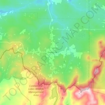
Name: Chartierville topographic map, elevation, terrain.

Location: Chartierville, Le Haut-Saint-François, Estrie, Quebec, J0B 1K0, Canada (45.23944 -71.34035 45.35178 -71.13092)

Average elevation: 591 m

Minimum elevation: 385 m

Maximum elevation: 1,018 m

Le Haut-Saint-François trails, hiking, mountain biking, running and outdoor activities

Other topographic maps

Click on a map to view its topography, its elevation and its terrain.
Island Brook

Canada > Quebec > Le Haut-Saint-François > Newport

Average elevation: 340 m

Island Brook

Canada > Quebec > Le Haut-Saint-François > Newport

Average elevation: 340 m

Maple Leaf

Canada > Quebec > Le Haut-Saint-François > Newport

Average elevation: 379 m

Gould

Canada > Quebec > Le Haut-Saint-François > Lingwick

Average elevation: 322 m

Gear up for your next adventure:

🚲Handlebar Phone Mount - View topographic-map.com live while cycling
🛌Insulated Sleeping Pad - Critical thermal barrier between you and the cold ground
🥾Trail Hiking Shoes - Durable shoes designed for rugged trails
🔨Vehicle Emergency Tool - Safety tool for remote road trips to trailheads
🦯Trekking Poles - Reduced impact on joints for steep topographic climbs

As an Amazon Associate, this site earns from qualifying purchases at no extra cost to you.