Geolocate

Shopian topographic map

Click on the map to display elevation.

About this map

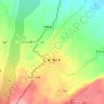
Name: Shopian topographic map, elevation, terrain.

Location: Shopian, Jammu and Kashmir, India (33.71300 74.82253 33.72867 74.84543)

Average elevation: 2,033 m

Minimum elevation: 1,976 m

Maximum elevation: 2,092 m

Other topographic maps

Click on a map to view its topography, its elevation and its terrain.

Nowpora

India > Jammu and Kashmir > Shopian

Average elevation: 1,727 m

Ramnagri

India > Jammu and Kashmir > Shopian

Average elevation: 2,087 m

Gear up for your next adventure:

🧥Softshell Hiking Jacket - The perfect balance of wind protection and breathability
🚲Heavy Duty Bike Lock - Secure your bike at the trailhead or during stops
🧳Compression Sacks - Maximize space in your backpack by shrinking gear
🪜Heavy Duty Carabiners - Multi-use clips for securing gear to your backpack
🥾Hiking Leggings - Comfortable leggings for outdoor activities

As an Amazon Associate, this site earns from qualifying purchases at no extra cost to you.