Geolocate

Murs topographic map

Click on the map to display elevation.

About this map
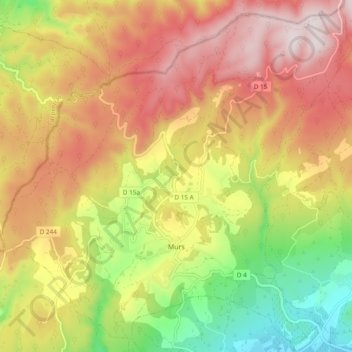
Name: Murs topographic map, elevation, terrain.

Location: Murs, Apt, Vaucluse, Provence-Alpes-Côte d'Azur, Metropolitan France, 84220, France (43.93224 5.19495 43.99762 5.29019)

Average elevation: 534 m

Minimum elevation: 229 m

Maximum elevation: 805 m

Other topographic maps

Click on a map to view its topography, its elevation and its terrain.

Gear up for your next adventure:

🧥Thermal Fleece Jacket - Versatile insulation for changing mountain temperatures
🥾All-Terrain Hiking Boots - Versatile boots for varied hiking conditions
🧣Evaporative Cooling Towel - Beat the heat during intense summer climbs
🧥Ultralight Puffy Jacket - Maximum warmth that packs down to the size of an orange
🦯Trekking Poles - Reduced impact on joints for steep topographic climbs

As an Amazon Associate, this site earns from qualifying purchases at no extra cost to you.