
Weimerskirch topographic map
Interactive map
Click on the map to display elevation.
About this map
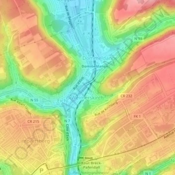
Name: Weimerskirch topographic map, elevation, terrain.
Location: Weimerskirch, Luxembourg, Canton Luxembourg, Luxembourg (49.62153 6.13073 49.63806 6.15804)
Average elevation: 306 m
Minimum elevation: 233 m
Maximum elevation: 371 m
Other topographic maps
Click on a map to view its topography, its elevation and its terrain.
Neudorf-Weimershof
Luxembourg > Canton Luxembourg > Luxembourg
Neudorf-Weimershof, Luxembourg, Canton Luxembourg, Luxembourg
Average elevation: 323 m
Cents
Luxembourg > Canton Luxembourg > Luxembourg
Cents, Luxembourg, Canton Luxembourg, Luxembourg
Average elevation: 315 m
Gasperich
Luxembourg > Canton Luxembourg > Luxembourg
Gasperich, Luxembourg, Canton Luxembourg, Luxembourg
Average elevation: 294 m
Beggen
Luxembourg > Canton Luxembourg > Luxembourg
Beggen, Luxembourg, Canton Luxembourg, Luxembourg
Average elevation: 295 m
Cessange
Luxembourg > Canton Luxembourg > Luxembourg
Cessange, Luxembourg, Canton Luxembourg, Luxembourg
Average elevation: 291 m