
Kandern topographic map
Click on the map to display elevation.
About this map
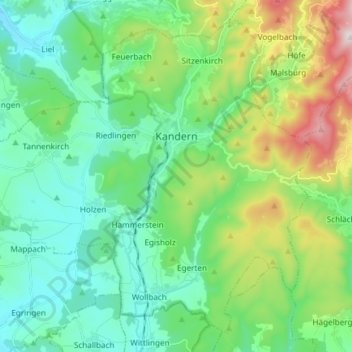
Name: Kandern topographic map, elevation, terrain.
Average elevation: 450 m
Minimum elevation: 250 m
Maximum elevation: 1,019 m
Other topographic maps
Click on a map to view its topography, its elevation and its terrain.
Blauen
Germany > Baden-Württemberg > Landkreis Lörrach
In the 14th century, the mountain was recorded as the Blauwen or Blawen. Matthäus Merian's Topographia Sueviae in the mid-17th century calls it the Hoche Blawen ("High Blawen"). The parish boundary plan of the first Baden state survey of 1769/1770 distinguishes between the Hoch Blauen ("High Blauen") and the…
Average elevation: 877 m
Nordschwaben
Germany > Baden-Württemberg > Landkreis Lörrach > Rheinfelden (Baden)
Average elevation: 446 m
Lippisbacher Hof
Germany > Baden-Württemberg > Landkreis Lörrach > Obereggenen
Average elevation: 645 m
Obertüllingen
Germany > Baden-Württemberg > Landkreis Lörrach > Lörrach > Untertüllingen
Average elevation: 307 m
Elbenschwand
Germany > Baden-Württemberg > Landkreis Lörrach > Kleines Wiesental
Average elevation: 789 m