
Make a donation
Gear up for your next adventure:
As an Amazon Associate, this site earns from qualifying purchases at no extra cost to you.
Cintruénigo topographic map
Click on the map to display elevation.
Make a donation
Gear up for your next adventure:
As an Amazon Associate, this site earns from qualifying purchases at no extra cost to you.
Cintruénigo
The village of Cintruénigo is situated in the autonomous community of Navarre within the Ribera de Navarra at an altitude of 391 MSL. Its area is of 35.4 km2 and limits to the north and northeast with the municipality of Corella, to the east and south with that of Tudela and to the west with that of Fitero.
Make a donation
Gear up for your next adventure:
As an Amazon Associate, this site earns from qualifying purchases at no extra cost to you.
About this map
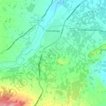
Name: Cintruénigo topographic map, elevation, terrain.
Location: Cintruénigo, Ribera / Erribera, Navarre, 31592, Spain (42.02904 -1.83733 42.10075 -1.74355)
Average elevation: 427 m
Minimum elevation: 362 m
Maximum elevation: 628 m
Make a donation
Gear up for your next adventure:
As an Amazon Associate, this site earns from qualifying purchases at no extra cost to you.