
Thank you for supporting this site ❤️
Make a donation
Make a donation
Gear up for your next adventure:
As an Amazon Associate, this site earns from qualifying purchases at no extra cost to you.
Asembo topographic map
Click on the map to display elevation.
Thank you for supporting this site ❤️
Make a donation
Make a donation
Gear up for your next adventure:
As an Amazon Associate, this site earns from qualifying purchases at no extra cost to you.
About this map
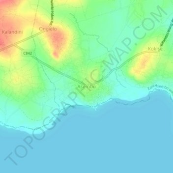
Name: Asembo topographic map, elevation, terrain.
Location: Asembo, East Asembo ward, Rarieda, Siaya County, Nyanza, Kenya (-0.20334 34.36571 -0.16334 34.40571)
Average elevation: 1,148 m
Minimum elevation: 1,131 m
Maximum elevation: 1,198 m
Thank you for supporting this site ❤️
Make a donation
Make a donation
Gear up for your next adventure:
As an Amazon Associate, this site earns from qualifying purchases at no extra cost to you.