
Make a donation
Gear up for your next adventure:
As an Amazon Associate, this site earns from qualifying purchases at no extra cost to you.
Mundaka topographic map
Click on the map to display elevation.
Make a donation
Gear up for your next adventure:
As an Amazon Associate, this site earns from qualifying purchases at no extra cost to you.
About this map
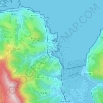
Name: Mundaka topographic map, elevation, terrain.
Average elevation: 60 m
Minimum elevation: -4 m
Maximum elevation: 322 m
Make a donation
Gear up for your next adventure:
As an Amazon Associate, this site earns from qualifying purchases at no extra cost to you.
Other topographic maps
Click on a map to view its topography, its elevation and its terrain.
Make a donation
Gear up for your next adventure:
As an Amazon Associate, this site earns from qualifying purchases at no extra cost to you.
Biaritz
Spanien > Autonome Gemeinschaft Baskenland > Arabako lautada / Llanada Alavesa > Agurain / Salvatierra
Average elevation: 599 m
Cabo Higuer
Spanien > Autonome Gemeinschaft Baskenland > Bidasoa Beherea / Bajo Bidasoa > Hondarribia/Fontarrabie
Average elevation: 12 m
La Mana
Spanien > Autonome Gemeinschaft Baskenland > Karrantza Harana / Valle de Carranza
Average elevation: 999 m