
Cibadak topographic map
Interactive map
Click on the map to display elevation.
About this map
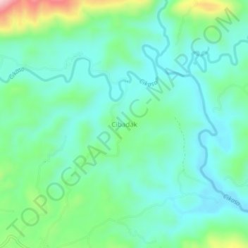
Name: Cibadak topographic map, elevation, terrain.
Location: Cibadak, Sukabumi, Java occidental, Indonésie (-7.17075 106.78923 -7.13075 106.82923)
Average elevation: 456 m
Minimum elevation: 380 m
Maximum elevation: 694 m
Other topographic maps
Click on a map to view its topography, its elevation and its terrain.
Banyuwangi
Indonésie > Java occidental > Sukabumi
Banyuwangi, Sukabumi, Java occidental, Indonésie
Average elevation: 199 m