
Thank you for supporting this site ❤️
Make a donation
Make a donation
Gear up for your next adventure:
As an Amazon Associate, this site earns from qualifying purchases at no extra cost to you.
Welling topographic map
Click on the map to display elevation.
Thank you for supporting this site ❤️
Make a donation
Make a donation
Gear up for your next adventure:
As an Amazon Associate, this site earns from qualifying purchases at no extra cost to you.
About this map
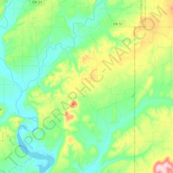
Name: Welling topographic map, elevation, terrain.
Location: Welling, Cherokee County, Oklahoma, 74471, United States (35.78794 -94.90269 35.92148 -94.80731)
Average elevation: 264 m
Minimum elevation: 192 m
Maximum elevation: 436 m
Thank you for supporting this site ❤️
Make a donation
Make a donation
Gear up for your next adventure:
As an Amazon Associate, this site earns from qualifying purchases at no extra cost to you.
Other topographic maps
Click on a map to view its topography, its elevation and its terrain.
No Head Hollow Public Use Area
United States > Oklahoma > Cherokee County > Tahlequah
Average elevation: 267 m