Geolocate

Maralal topographic map

Click on the map to display elevation.

About this map

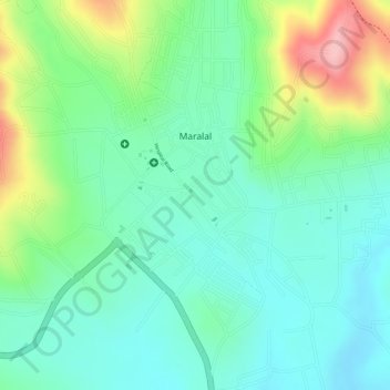
Name: Maralal topographic map, elevation, terrain.

Location: Maralal, Maralal ward, Samburu Central, Samburu, Kenya (1.08399 36.68706 1.10779 36.70876)

Average elevation: 1,956 m

Minimum elevation: 1,897 m

Maximum elevation: 2,082 m

Gear up for your next adventure:

🧥Thermal Fleece Jacket - Versatile insulation for changing mountain temperatures
🧢Hiking Hat - Sun-protective and breathable hats for long treks
🛏️Sleeping Bag - Warm and compact sleeping bags for outdoor camping
🧥Insulated Jacket - Keep warm in cold outdoor conditions
💧Filtered Water Bottle - Safe drinking water on the go

As an Amazon Associate, this site earns from qualifying purchases at no extra cost to you.