Geolocate

Princeton topographic map

Click on the map to display elevation.

Princeton

The average altitude of Princeton is 2400 ft, with highest points at 3100 ft and lowest points at 1700 ft, above sea level.

Wikipedia (CC-BY-SA 3.0)

About this map

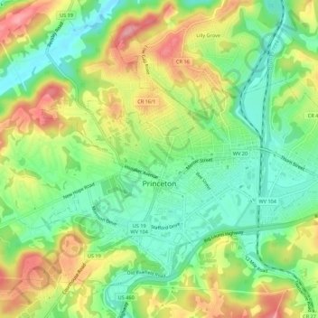
Name: Princeton topographic map, elevation, terrain.

Location: Princeton, Mercer County, West Virginia, 24740, United States (37.35120 -81.12282 37.38811 -81.06826)

Average elevation: 761 m

Minimum elevation: 708 m

Maximum elevation: 832 m

Other topographic maps

Click on a map to view its topography, its elevation and its terrain.

Flat Top

United States > West Virginia > Mercer County

Average elevation: 962 m

Flipping

United States > West Virginia > Mercer County > Montcalm

Average elevation: 752 m

Rock

United States > West Virginia > Mercer County

Average elevation: 760 m

Willowton

United States > West Virginia > Mercer County

Average elevation: 654 m

Beeson

United States > West Virginia > Mercer County

Average elevation: 798 m

Freeman

United States > West Virginia > Mercer County > Bramwell

Average elevation: 762 m

Dunns

United States > West Virginia > Mercer County > Dunns

Average elevation: 675 m

Gear up for your next adventure:

💧Filtered Water Bottle - Safe drinking water on the go
🥾Trail Running Boots - Durable shoes designed for trail running
🛌Down Sleeping Bag - Superior warmth-to-weight ratio for cold nights
🧦Thermal Socks - Warm socks for winter hiking or camping
👟Leg Gaiters - Keep debris, mud, and snow out of your boots

As an Amazon Associate, this site earns from qualifying purchases at no extra cost to you.