Geolocate

Namia topographic map

Click on the map to display elevation.

About this map

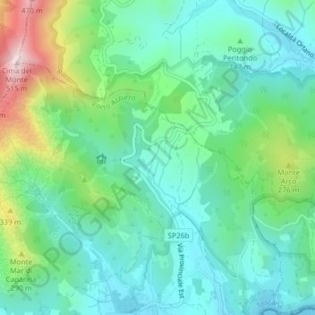
Name: Namia topographic map, elevation, terrain.

Location: Namia, Porto Azzurro, Livorno, Tuscany, 57036, Italy (42.77679 10.39676 42.79679 10.41676)

Average elevation: 133 m

Minimum elevation: 0 m

Maximum elevation: 500 m

Gear up for your next adventure:

🧭Orienteering Kit - Tools for map reading and navigation in the wild
🔋Lithium AA Batteries - Long-lasting power that performs in extreme cold
🧳Compression Sacks - Maximize space in your backpack by shrinking gear
🧰Multitool Knife - Compact and versatile tool for outdoor use
🧰Survival Kit - Essential gear for emergencies in the wilderness

As an Amazon Associate, this site earns from qualifying purchases at no extra cost to you.