
Make a donation
Gear up for your next adventure:
As an Amazon Associate, this site earns from qualifying purchases at no extra cost to you.
Alto Bonito topographic map
Click on the map to display elevation.
Make a donation
Gear up for your next adventure:
As an Amazon Associate, this site earns from qualifying purchases at no extra cost to you.
About this map
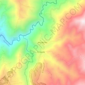
Name: Alto Bonito topographic map, elevation, terrain.
Average elevation: 1,795 m
Minimum elevation: 1,300 m
Maximum elevation: 2,247 m
Make a donation
Gear up for your next adventure:
As an Amazon Associate, this site earns from qualifying purchases at no extra cost to you.
Other topographic maps
Click on a map to view its topography, its elevation and its terrain.
Comuna Atardeceres
Colombia > Caldas > Manizales > Perímetro Urbano Manizales
Average elevation: 1,913 m
Comuna Ecoturística Cerro de Oro
Colombia > Caldas > Manizales > Perímetro Urbano Manizales
Average elevation: 2,174 m
Make a donation
Gear up for your next adventure:
As an Amazon Associate, this site earns from qualifying purchases at no extra cost to you.
Comuna Universitaria
Colombia > Caldas > Manizales > Perímetro Urbano Manizales
Average elevation: 1,977 m
Comuna Ecoturística Cerro de Oro
Colombia > Caldas > Manizales > Perímetro Urbano Manizales
Average elevation: 2,174 m
Comuna Ecoturística Cerro de Oro
Colombia > Caldas > Manizales > Perímetro Urbano Manizales
Average elevation: 2,174 m
Make a donation
Gear up for your next adventure:
As an Amazon Associate, this site earns from qualifying purchases at no extra cost to you.
Comuna Universitaria
Colombia > Caldas > Manizales > Perímetro Urbano Manizales
Average elevation: 1,977 m