Geolocate

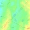
Point Turton topographic map

Click on the map to display elevation.

About this map

Name: Point Turton topographic map, elevation, terrain.

Location: Point Turton, Yorke Peninsula Council, South Australia, 5575, Australia (-34.97019 137.29764 -34.91979 137.40109)

Average elevation: 12 m

Minimum elevation: 0 m

Maximum elevation: 57 m

Other topographic maps

Click on a map to view its topography, its elevation and its terrain.
Gear up for your next adventure:

🏃Hydration Running Vest - Carry water and maps close to your body for speed
🥤Collapsible Travel Cup - Saves space and weight in your mess kit
🧥Fleece Jacket - Warm and lightweight jacket for layering
🧣Evaporative Cooling Towel - Beat the heat during intense summer climbs
🔋Lithium AA Batteries - Long-lasting power that performs in extreme cold

As an Amazon Associate, this site earns from qualifying purchases at no extra cost to you.