
Make a donation
Gear up for your next adventure:
As an Amazon Associate, this site earns from qualifying purchases at no extra cost to you.
Municipio Macanao topographic map
Click on the map to display elevation.
Make a donation
Gear up for your next adventure:
As an Amazon Associate, this site earns from qualifying purchases at no extra cost to you.
About this map
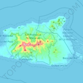
Name: Municipio Macanao topographic map, elevation, terrain.
Location: Municipio Macanao, Estado Nueva Esparta, Venezuela (10.92610 -64.41718 11.09436 -64.16722)
Average elevation: 34 m
Minimum elevation: -2 m
Maximum elevation: 706 m
Make a donation
Gear up for your next adventure:
As an Amazon Associate, this site earns from qualifying purchases at no extra cost to you.
Other topographic maps
Click on a map to view its topography, its elevation and its terrain.
La Plaza Paraguachí
Venezuela > Estado Nueva Esparta > Municipio Antolín del Campo
Average elevation: 133 m
Salinas de Pampatar
Venezuela > Estado Nueva Esparta > Municipio Maneiro > Pampatar
Average elevation: 6 m
Make a donation
Gear up for your next adventure:
As an Amazon Associate, this site earns from qualifying purchases at no extra cost to you.
Make a donation
Gear up for your next adventure:
As an Amazon Associate, this site earns from qualifying purchases at no extra cost to you.
San Antonio
Venezuela > Estado Nueva Esparta > Municipio García > San Antonio
Average elevation: 110 m
La Mira
Venezuela > Estado Nueva Esparta > Municipio Antolín del Campo > La Mira
Average elevation: 66 m
Make a donation
Gear up for your next adventure:
As an Amazon Associate, this site earns from qualifying purchases at no extra cost to you.
Playa Guacuco
Venezuela > Estado Nueva Esparta > Municipio Arismendi > El Conchal
Average elevation: 29 m
Make a donation
Gear up for your next adventure:
As an Amazon Associate, this site earns from qualifying purchases at no extra cost to you.
Playa Bahía de Plata
Venezuela > Estado Nueva Esparta > Municipio Gómez > Altagracia
Average elevation: 13 m