Geolocate

Winterset topographic map

Click on the map to display elevation.

About this map

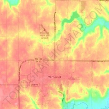
Name: Winterset topographic map, elevation, terrain.

Location: Winterset, Madison County, Iowa, 50273, United States (41.31858 -94.04238 41.35513 -93.99837)

Average elevation: 336 m

Minimum elevation: 274 m

Maximum elevation: 353 m

Other topographic maps

Click on a map to view its topography, its elevation and its terrain.

Barney

United States > Iowa > Madison County

Average elevation: 346 m

Gear up for your next adventure:

💧Collapsible Water Bottle - Space-saving water bottle for outdoor activities
🧰Multitool Knife - Compact and versatile tool for outdoor use
🌡️Emergency Mylar Blankets - Compact thermal protection for unexpected nights outdoors
🧣Merino Neck Gaiter - Protects against wind, sun, and cold at high altitudes
🕯️Camping Lantern - Illuminates your entire campsite with high-efficiency LEDs

As an Amazon Associate, this site earns from qualifying purchases at no extra cost to you.