
Make a donation
Gear up for your next adventure:
As an Amazon Associate, this site earns from qualifying purchases at no extra cost to you.
Santa topographic map
Click on the map to display elevation.
Make a donation
Gear up for your next adventure:
As an Amazon Associate, this site earns from qualifying purchases at no extra cost to you.
About this map
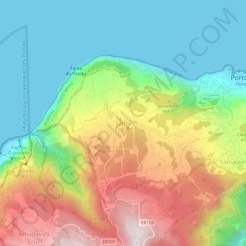
Name: Santa topographic map, elevation, terrain.
Location: Santa, Porto Moniz, Madeira, 9270-093, Portugal (32.83956 -17.21116 32.87956 -17.17116)
Average elevation: 313 m
Minimum elevation: 0 m
Maximum elevation: 823 m
Make a donation
Gear up for your next adventure:
As an Amazon Associate, this site earns from qualifying purchases at no extra cost to you.
Other topographic maps
Click on a map to view its topography, its elevation and its terrain.
Achadas da Cruz
Achadas da Cruz é uma freguesia portuguesa do município do Porto Moniz, com 10,00 km² de área e 121 habitantes (2021). A sua densidade populacional é 22,0 hab/km². Localiza-se a uma latitude 32.833 (32°50') Norte e a uma longitude 17.21667 (17°13') Oeste, estando a uma altitude de 575 metros. Achadas…
Average elevation: 568 m
Make a donation
Gear up for your next adventure:
As an Amazon Associate, this site earns from qualifying purchases at no extra cost to you.