
Town of Manheim topographic map
Interactive map
Click on the map to display elevation.
About this map
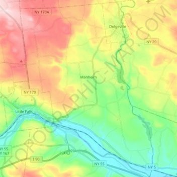
Name: Town of Manheim topographic map, elevation, terrain.
Location: Town of Manheim, Herkimer County, New York, United States (42.99932 -74.86333 43.11876 -74.74019)
Average elevation: 246 m
Minimum elevation: 89 m
Maximum elevation: 474 m
Other topographic maps
Click on a map to view its topography, its elevation and its terrain.
Mink Lake
United States > New York > Herkimer County > Town of Ohio
Mink Lake, Town of Ohio, Herkimer County, New York, United States
Average elevation: 518 m
Salmon Lake
United States > New York > Herkimer County
Salmon Lake, Town of Webb, Herkimer County, New York, United States
Average elevation: 576 m
Sunday Lake
United States > New York > Herkimer County
Sunday Lake, Town of Webb, Herkimer County, New York, United States
Average elevation: 515 m