
Roku topographic map
Interactive map
Click on the map to display elevation.
About this map
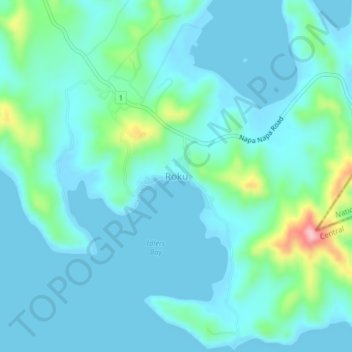
Name: Roku topographic map, elevation, terrain.
Location: Roku, Central, Southern Region, Papua New Guinea (-9.47955 147.07030 -9.43955 147.11030)
Average elevation: 31 m
Minimum elevation: 0 m
Maximum elevation: 193 m
Other topographic maps
Click on a map to view its topography, its elevation and its terrain.
Sogeri
Papua New Guinea > Central > Sogeri
Sogeri, Central, Southern Region, Papua New Guinea
Average elevation: 522 m
Laloki River
Laloki River, Port Moresby District, Central, Papua Region, Papua New Guinea
Average elevation: 352 m
Owen Stanley Range
Owen Stanley Range, Port Moresby District, Central, Papua Region, Papua New Guinea
Average elevation: 2,450 m