
Thank you for supporting this site ❤️
Make a donation
Make a donation
Gear up for your next adventure:
As an Amazon Associate, this site earns from qualifying purchases at no extra cost to you.
Vokopolë topographic map
Click on the map to display elevation.
Thank you for supporting this site ❤️
Make a donation
Make a donation
Gear up for your next adventure:
As an Amazon Associate, this site earns from qualifying purchases at no extra cost to you.
About this map
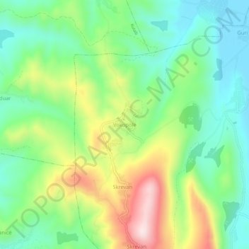
Name: Vokopolë topographic map, elevation, terrain.
Location: Vokopolë, Bashkia Ura Vajgurore, Berat County, 5007, Albania (40.74055 19.80545 40.78055 19.84545)
Average elevation: 173 m
Minimum elevation: 27 m
Maximum elevation: 440 m
Thank you for supporting this site ❤️
Make a donation
Make a donation
Gear up for your next adventure:
As an Amazon Associate, this site earns from qualifying purchases at no extra cost to you.