Geolocate

Pontellas topographic map

Click on the map to display elevation.

About this map

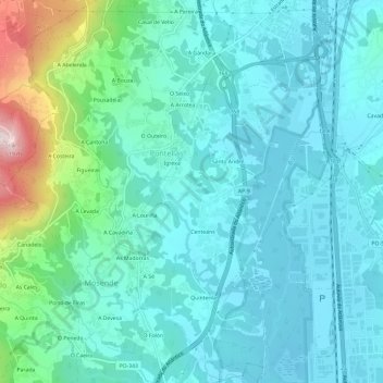
Name: Pontellas topographic map, elevation, terrain.

Location: Pontellas, Porriño, Vigo, Pontevedra, Galicia, 36412, España (42.11097 -8.67000 42.15494 -8.62460)

Average elevation: 100 m

Minimum elevation: 8 m

Maximum elevation: 514 m

Other topographic maps

Click on a map to view its topography, its elevation and its terrain.

Aviseiro

España > Galicia > Vigo > Porriño

Average elevation: 78 m

A Costeira

España > Galicia > Vigo > Porriño

Average elevation: 243 m

As Gándaras de Budiño

España > Galicia > Vigo > Porriño > Quintenla

Average elevation: 32 m

Canadelo

España > Galicia > Vigo > Porriño

Average elevation: 267 m

As Filgueiras

España > Galicia > Vigo > Porriño

Average elevation: 341 m

A Cantoña

España > Galicia > Vigo > Porriño

Average elevation: 208 m

Pego

España > Galicia > Vigo > Porriño

Average elevation: 76 m

Gear up for your next adventure:

🥾Hiking Shorts - Breathable shorts suitable for summer hikes
🔋Lithium AA Batteries - Long-lasting power that performs in extreme cold
🔦LED Headlamp - Hands-free lighting for early morning starts or late finishes
🥾Approach Boots - Comfortable boots for hiking and climbing approaches
🧭GPS Tracker - Track your location in remote areas safely

As an Amazon Associate, this site earns from qualifying purchases at no extra cost to you.