
Tequesta topographic map
Click on the map to display elevation.
About this map
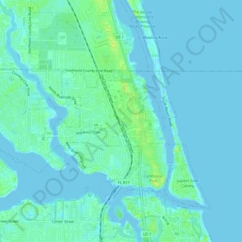
Name: Tequesta topographic map, elevation, terrain.
Location: Tequesta, Palm Beach County, Florida, 33469, United States (26.95078 -80.12647 26.97092 -80.07418)
Average elevation: 4 m
Minimum elevation: -8 m
Maximum elevation: 15 m
Other topographic maps
Click on a map to view its topography, its elevation and its terrain.
Delray Beach
United States > Florida > Palm Beach County > Delray Beach
Delray Beach has hot and humid summers. High summertime temperatures range from 87-93 °F with low temperatures around 75-78 °F. Winters are warm, with a marked drier season. Typical wintertime high temperatures are typically in the range of 74-83 °F and low temperatures 57-65 °F. However, when occasional…
Average elevation: 4 m
Villages of Oriole
United States > Florida > Palm Beach County > Villages of Oriole
Average elevation: 9 m
Oslo national park
United States > Florida > Palm Beach County > West Palm Beach
Average elevation: 9 m