
Make a donation
Gear up for your next adventure:
As an Amazon Associate, this site earns from qualifying purchases at no extra cost to you.
Igstadt topographic map
Click on the map to display elevation.
Make a donation
Gear up for your next adventure:
As an Amazon Associate, this site earns from qualifying purchases at no extra cost to you.
Igstadt
Igstadt is situated on the eastern slope of the Wäschbachtal valley at an elevation of 169 to 211 m above sea level. It is traversed by the Wiesbaden-Niedernhausen rail line. It is surrounded by agricultural land. Recreational areas include the Wickerbachtal Nature Reserve between Igstadt and Kloppenheim.
Make a donation
Gear up for your next adventure:
As an Amazon Associate, this site earns from qualifying purchases at no extra cost to you.
About this map
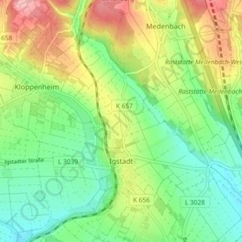
Name: Igstadt topographic map, elevation, terrain.
Location: Igstadt, Wiesbaden, Hesse, Germany (50.06797 8.30660 50.10916 8.35590)
Average elevation: 198 m
Minimum elevation: 149 m
Maximum elevation: 274 m
Make a donation
Gear up for your next adventure:
As an Amazon Associate, this site earns from qualifying purchases at no extra cost to you.
Other topographic maps
Click on a map to view its topography, its elevation and its terrain.