
Monrovia topographic map
Click on the map to display elevation.
About this map
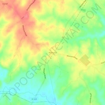
Name: Monrovia topographic map, elevation, terrain.
Location: Monrovia, Orange County, Virginia, United States (38.13514 -78.01889 38.17514 -77.97889)
Average elevation: 109 m
Minimum elevation: 76 m
Maximum elevation: 143 m
Other topographic maps
Click on a map to view its topography, its elevation and its terrain.
Barboursville Community Park
United States > Virginia > Orange County > Barboursville
Average elevation: 158 m