Geolocate

Pandaan topographic map

Click on the map to display elevation.

About this map

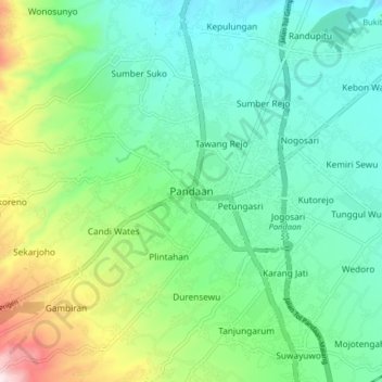
Name: Pandaan topographic map, elevation, terrain.

Location: Pandaan, Pasuruan, East Java, Java, 67161, Indonesia (-7.69323 112.64729 -7.61323 112.72729)

Average elevation: 216 m

Minimum elevation: 60 m

Maximum elevation: 632 m

Other topographic maps

Click on a map to view its topography, its elevation and its terrain.

Batas Desa Sumberanyar

Indonesia > East Java > Pasuruan

Average elevation: 39 m

Gear up for your next adventure:

💧Collapsible Water Bottle - Space-saving water bottle for outdoor activities
🥾Approach Shoes - Shoes designed for climbing approaches and rugged trails
❄️Traction Ice Cleats - Slip-on spikes for icy trails and winter hiking
🛌Down Sleeping Bag - Superior warmth-to-weight ratio for cold nights
🧤Insulated Winter Gloves - Heavy-duty protection for sub-zero Canadian adventures

As an Amazon Associate, this site earns from qualifying purchases at no extra cost to you.