Geolocate

Shenchen topographic map

Click on the map to display elevation.

About this map

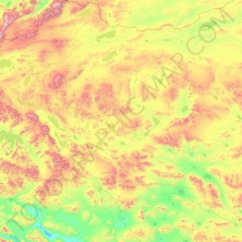
Name: Shenchen topographic map, elevation, terrain.

Location: Shenchen, Gêrzê County, Ngari Prefecture, Tibet, China (32.73097 81.98199 35.71796 83.84113)

Average elevation: 5,074 m

Minimum elevation: 4,376 m

Maximum elevation: 6,908 m

Other topographic maps

Click on a map to view its topography, its elevation and its terrain.

Sijia Lake

China > Tibet > Gêrzê County > Shenchen

Average elevation: 4,898 m

Gear up for your next adventure:

🥾Mountain Hiking Boots - High-traction boots for rocky terrain
Backpacking Tent - Lightweight tent for long-distance hiking trips
🥾Hiking Leggings - Comfortable leggings for outdoor activities
🧊Portable Cooler - Keep food and drinks cold during outdoor adventures
Camping Coffee Maker - Brew fresh coffee anywhere on the topographic map

As an Amazon Associate, this site earns from qualifying purchases at no extra cost to you.